Week 6 - Projections Part II
With more than 1,500 map projections to choose from -- it's no wonder this subject matter is deemed the most daunting in GIS studies. However, thanks to this week's lesson, I got a solid understanding of the most important things to remember:
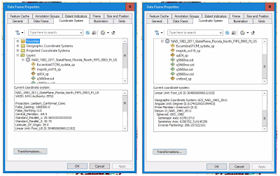
After downloading this data and bringing it into ArcGIS Desktop, we learned that some of the data was either already defined into a projection, or it was completely missing a spatial reference. Our ultimate goal in our lab was to prove mastery in being able to apply all of these data formats under one common spatial reference. As you can see in the screenshot to the right, I was successful in achieving this task.
The image below illustrates all of the data I worked with: a point shapefile of petroleum storage tank contamination monitoring (STCM) sites in Escambia County, United States Geological Survey's Quarter-Quad Index, DEP Quad #5660 named "Bratt" in Escambia County, major roads polyline shapefile and a county boundaries polygon shapefile of the state of Florida. All of my data was spatially referenced to the same projection of NAD 1983 (2011) State Plane Florida North FIPS 0903 Feet US.
- There are 4 main projection categories, and each one is generally used for showing specific areas of the world:
- Azimuthal - best for showing the polar areas of the world;
- Conic - best for showing mid-latitude areas of the world;
- Cylindrical - best for showing the whole world; and
- Mathematical - best for showing the whole world as well.
- There are also 4 basic properties in map projections:
- Equivalency, 2. Conformality, 3. Equidistance, and 4. True direction.
- Out of these four basic map properties, equivalency (equal area) and conformality (true shape), are in fact impossible to achieve together on a map projection.

After downloading this data and bringing it into ArcGIS Desktop, we learned that some of the data was either already defined into a projection, or it was completely missing a spatial reference. Our ultimate goal in our lab was to prove mastery in being able to apply all of these data formats under one common spatial reference. As you can see in the screenshot to the right, I was successful in achieving this task.
The image below illustrates all of the data I worked with: a point shapefile of petroleum storage tank contamination monitoring (STCM) sites in Escambia County, United States Geological Survey's Quarter-Quad Index, DEP Quad #5660 named "Bratt" in Escambia County, major roads polyline shapefile and a county boundaries polygon shapefile of the state of Florida. All of my data was spatially referenced to the same projection of NAD 1983 (2011) State Plane Florida North FIPS 0903 Feet US.

Comments
Post a Comment