Week 5 - Georeferencing & Projections Part I
This week we covered some pretty intense major topics: datums, ellipsoids, geoids, coordinate systems, map projections and more.
Because our world is an "oblate ellipsoid", with non-smooth surfaces, valleys, great ocean depths, and strong gravitational fields, geodesists and other great mathematicians from the past have established physical references on earth so that we can accurately measure things -- especially when we flatten our 3-D world onto a piece of paper. These collections of points (or datums) are what formed our coordinate systems; some of the most commonly used are the World Geodetic System of 1984 (WGS84), the North American Datum of 1983 (NAD83), and the Cartesian Coordinate System.
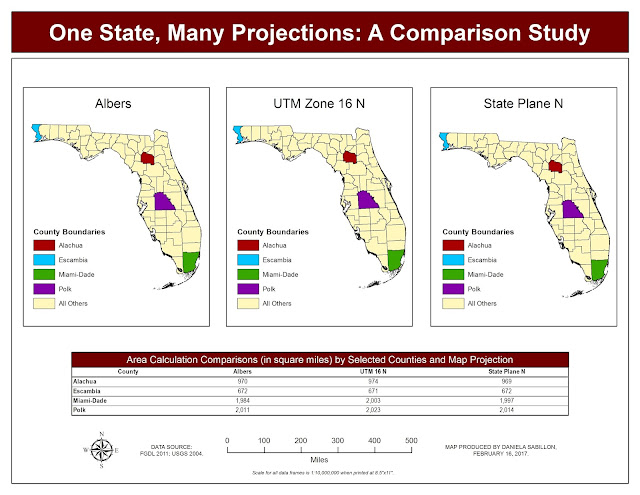
So for our lab assignment, we were tasked to apply 3 different projections in one map document, and calculate geometry for 4 counties, for each of the projections. This lab really showed us how different projections can cause different types of distortions. Because of this inconsistency, it is important to note the projections (or lack thereof) of the geographic data we are working with so that our spatial analysis can stay consistent and be accurate. To a novice GIS user, 3-10 square miles of differences may not seem like a big deal, but depending on the stakeholder using the data provided, it is: whether it’s buying flood insurance for your home, or routing an ambulance to save a life; the more accurate, the better. Of course, everything is relative. The Universal Transverse Mercator (UTM) projection is a commonly used cylindrical projection by counties. The Albers Conical Equal Area projection on the other hand, is a global projection that accurately represents areas around the world, making it an ideal fit to represent the entire State of Florida. And finally, the State Plane Coordinate System is used most for federal, state, and local large-scale mapping projects in the United States. So how do we figure out which spatial reference to use in a “real life GIS job setting”? Typically (and thankfully), this information is included in some kind of document packaged with the GIS data you are downloading.
Because our world is an "oblate ellipsoid", with non-smooth surfaces, valleys, great ocean depths, and strong gravitational fields, geodesists and other great mathematicians from the past have established physical references on earth so that we can accurately measure things -- especially when we flatten our 3-D world onto a piece of paper. These collections of points (or datums) are what formed our coordinate systems; some of the most commonly used are the World Geodetic System of 1984 (WGS84), the North American Datum of 1983 (NAD83), and the Cartesian Coordinate System.
So for our lab assignment, we were tasked to apply 3 different projections in one map document, and calculate geometry for 4 counties, for each of the projections. This lab really showed us how different projections can cause different types of distortions. Because of this inconsistency, it is important to note the projections (or lack thereof) of the geographic data we are working with so that our spatial analysis can stay consistent and be accurate. To a novice GIS user, 3-10 square miles of differences may not seem like a big deal, but depending on the stakeholder using the data provided, it is: whether it’s buying flood insurance for your home, or routing an ambulance to save a life; the more accurate, the better. Of course, everything is relative. The Universal Transverse Mercator (UTM) projection is a commonly used cylindrical projection by counties. The Albers Conical Equal Area projection on the other hand, is a global projection that accurately represents areas around the world, making it an ideal fit to represent the entire State of Florida. And finally, the State Plane Coordinate System is used most for federal, state, and local large-scale mapping projects in the United States. So how do we figure out which spatial reference to use in a “real life GIS job setting”? Typically (and thankfully), this information is included in some kind of document packaged with the GIS data you are downloading.

Comments
Post a Comment