Lab 2 - Organizational Structure, Governance, Coordination & Legal Issues
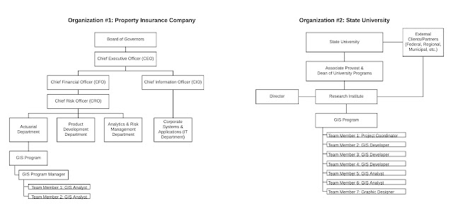
- Created organizational charts from two given characteristics of two different organizational types (pictured above);
- Learned how to respond to change by preparing a response plan from the perspective of a GIS Manager;
- Identified a current GIS program, then learned and summarized their associated data distribution policy plan addressing the legal concerns involved with derived, created, and distributed data; and
- Learned how to recognize and discuss potential legal/ethical/security concerns that a project, like AIDSVu, may encounter.
On that note, given the design and exposure of information of the AIDSVu application, some of the legal, ethical, and security concerns this project may encounter per Croswell (2009), include:
·
Compliance
with state laws that influence the requirements and restrictions on distributed
GIS data.
·
Liability
claims by users of the AIDSVu application.
·
Legally
protecting the AIDSVu GIS application and its data as intellectual property;
copyright the product to prevent illegal use from unauthorized users.
·
Records
retention laws and policies for appropriate storage and disposal of GIS data
and products.
·
Professional
licensure and/or involvement with organizations like the National Council of
Examiners for Engineering and Surveying (NCEES) and Management
Association for Private Photogrammetric Surveyors (MAPPS) to enforce strict
qualifications on individuals and organizations providing GIS services. (p.
145-154)
References
Croswell, P. L. (2009). The GIS
management handbook: Concepts, practices, and tools for planning, implementing,
and managing geographic information system projects and programs.
Frankfort, KY: Kessey Dewitt Publications.

I enjoyed your blog Thanks for sharing such an informative post. myntra org chart
ReplyDelete